Local brief
Flash Flood Warning: Henderson County, NC — flooding now or soon, until 11 a.m. EDT Sunday, Oct. 11
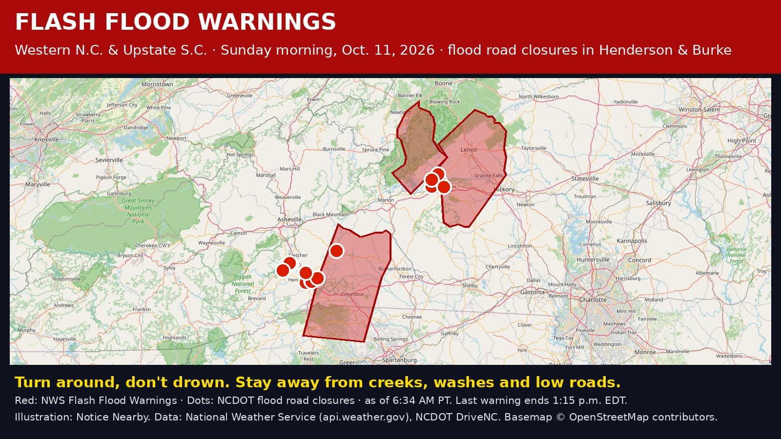
The National Weather Service has a Flash Flood Warning for Henderson County, North Carolina, until 11 a.m. EDT Sunday, Oct. 11 (8 a.m. PDT). Heavy rain is making creeks, washes and roads flood fast. Turn around, don't drown.
What is happening: Heavy rain is falling on ground that is already soaked from days of rain. The National Weather Service office in Greenville-Spartanburg says flash flooding is happening now or will start soon. NWS calls this life-threatening flash flooding and says significant flooding that could reach some buildings may develop quickly, and evacuations may be needed. Seek higher ground now. This rainfall will be capable of producing 1-2 inches in less than an hour.
Where: The warning covers eastern Henderson County. Places NWS named include Columbus, Landrum, Tryon, Lake Lure, Campobello, Saluda, Chimney Rock Village, Chimney Rock State Park, Bat Cave and Lake Bowen.
Until when: The warning lasts until 11 a.m. EDT Sunday, Oct. 11 (8 a.m. PDT). NWS can extend it or end it early, so check for updates.

Landslides: NWS says more heavy rain raises the risk of landslides and debris flows, especially where slides have happened before. If you hear rumbling, cracking trees or rocks moving, get away from the path of the slide right away.
Lake Lure Dam: At 7:30 a.m. EDT Sunday (4:30 a.m. PDT), Rutherford County Emergency Management, in a message relayed by NC Emergency Management, said Lake Lure officials were widening the dam's tainter gate openings from 3 feet to 6 feet, sending more water into the Broad River below Lake Lure Dam. What that means: if you live, work or are staying along the Broad River downstream of the dam, county officials say to expect rising water, faster river flows and possible flooding in low-lying areas, and that water may rise quickly with little warning. What to do now: move away from the river and get to higher ground if you are in a flood-prone area, stay off riverbanks and away from fast-moving water, do not drive through flooded roads, and keep watching water levels and official alerts.
Sirens back on: At 7:15 a.m. EDT Sunday (4:15 a.m. PDT), Rutherford County Emergency Management, in a message relayed by NC Emergency Management, said it was reactivating the flash flood warning sirens in the Fall Creek area north of Chimney Rock after another round of heavy rain, with special attention to Chimney Rock and Bat Cave. It urged people near the Rocky Broad River and nearby low-lying areas to move away from the river and seek higher ground immediately, and said water can rise with little or no warning.
Chimney Rock sirens, Saturday night: Rutherford County Emergency Management first turned on its flash flood warning sirens at about 10:20 p.m. EDT Saturday for the Fall Creek area just north of Chimney Rock. It told people there to move away from the river and get to higher ground right away. If you are near the Rocky Broad River in the Chimney Rock and Lake Lure area, watch water levels closely; they can rise with little warning.
Local reports: McDowell County Emergency Management said at 5:17 a.m. EDT Sunday (2:17 a.m. PDT) that heavy rain overnight caused flash flooding across parts of the county. More than 7 inches of rain fell in the Sugar Hill, Zion Hill and Crooked Creek communities, and 4 to 6 inches fell across much of the rest of the county. More heavy rain was expected before sunrise, and water levels were still high. Late Saturday, NC Emergency Management also reported landslides in McDowell County.
Roads closed by flooding: NCDOT lists these Henderson County roads as fully closed (all lanes) because of flooding as of 6:05 a.m. PDT Sunday, Oct. 11: NC 225 (Greenville Highway) from White St to US 176; White St from Kanuga Rd to NC 225; NC 9 eastbound from Bat Cave Dr to the Broad River; Hooper Ln from NC 191 to Jeffress Rd; Jeffress Rd from Majestic Ridge Rd to Hooper Ln; New Hope Rd from Blue Ridge St to Duncan Rd; Airport Rd from College Dr to Grandeur Ln; Turnpike Rd from Warlick Rd to Wilderness Dr; Dana Rd from US 64 to Tracy Grove Rd; Balfour Rd from Capps Ln to Carter St. NCDOT estimates most will reopen between about 9 and 9:45 a.m. EDT; Dana Rd (closed about 6:54 a.m. EDT) and Balfour Rd (closed about 7:02 a.m. EDT) are estimated to reopen around 7 p.m. EDT. Closures can last longer. Do not drive around barricades. Check https://www.drivenc.gov before you go.
Earlier warnings: The earlier NWS warning that ran until 5:15 a.m. EDT Sunday, Oct. 11 (2:15 a.m. PDT) (Hendersonville, Brevard, Columbus, Mills River, Fletcher, Flat Rock, Etowah, Mountain Home, Laurel Park and Tryon) has ended. The earlier NWS warning that ran until 7:15 a.m. EDT Sunday, Oct. 11 (4:15 a.m. PDT) (Lake Lure, Chimney Rock Village, Chimney Rock State Park, Bat Cave, Gerton, and Shingle Hollow) has ended.
What to do: Turn around, don't drown. Never drive or walk into floodwater. Six inches of moving water can knock you down, and one to two feet can carry away a car. Stay away from creeks, streams, washes, rivers and low roads. Do not drive around barricades. If water starts rising near you, go to higher ground right away. Flooded roads are hard to see in the dark.
Stay informed: Check https://www.weather.gov/gsp/ for the latest from the National Weather Service, and follow ReadyNC from NC Emergency Management (https://www.readync.gov) and your county emergency management office. Turn on emergency alerts on your phone and keep it charged.
Find shelters and supplies: https://zost.app/pages/nc/henderson
Sources: National Weather Service Greenville-Spartanburg Flash Flood Warning via api.weather.gov (https://api.weather.gov/alerts/urn:oid:2.49.0.1.840.0.1acbb200c8314703ddbeca7d1577046e55e11c2e.001.1); NC Emergency Management on X relaying McDowell County Emergency Management (https://x.com/NCEmergency/status/2109214558610952538), its 10:50 p.m. Saturday update (https://x.com/NCEmergency/status/2109115218051649796) and Rutherford County Emergency Management (https://x.com/NCEmergency/status/2109107480420659465), and its 7:15 a.m. relay of Rutherford County Emergency Management's siren reactivation (https://x.com/NCEmergency/status/2109246760291836115); NC Emergency Management's 7:30 a.m. relay of Rutherford County Emergency Management's Lake Lure Dam update (https://x.com/NCEmergency/status/2109248815320490086); NCDOT DriveNC event pages (https://www.drivenc.gov/Event/2576897, https://www.drivenc.gov/Event/2576896, https://www.drivenc.gov/Event/2576887, https://www.drivenc.gov/Event/2576891, https://www.drivenc.gov/Event/2576893, https://www.drivenc.gov/Event/2576890, https://www.drivenc.gov/Event/2576889, https://www.drivenc.gov/Event/2576888, https://www.drivenc.gov/Event/2576921, https://www.drivenc.gov/Event/2576925) and @NCDOT_Asheville on X. Updated 6:05 a.m. PDT Sunday, Oct. 11. Notice Nearby wrote this brief in its own words. More Henderson County notices: https://noticenearby.com/nc/henderson
Source: the public notice on this register NN-ENV-nc-henderson-flash-flood-warning-2026-10- · National Weather Service Greenville-Spartanburg Flash Flood Warning.
This is a Notice Nearby local brief — an in-house explainer written from a government-posted notice on this register. It is not official minutes, not a newspaper story, and not Legal Publication.