Ongoing paper · Updated 5 p.m. PT Saturday, Oct. 10 · NHC Intermediate Advisory 55A · Tropical Storm Rachel · 65 mph
Tropical Storm Rachel holding steady and moving quickly north-northeastward; Tropical Storm Watch for San Diego County — NHC Intermediate Advisory 55A
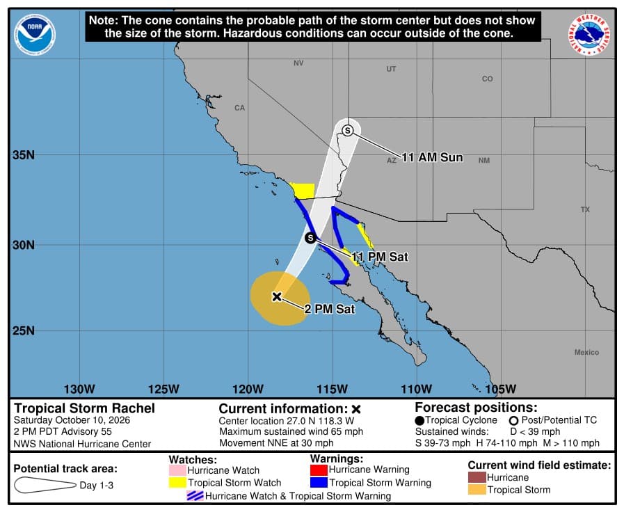
Tropical Storm Rachel was about 365 miles south of San Diego, California at 5 p.m. PT Saturday, Oct. 10 (NHC Intermediate Advisory 55A), with top sustained winds near 65 mph, moving north-northeast at 30 mph. On the forecast track, the center of Rachel is expected to approach northern Baja California later today and move onshore tonight. Rachel's post-tropical remnants will then move across the southwestern United States on Sunday. In California, the National Weather Service has a Coastal Flood Warning for Los Angeles, Orange and San Diego counties, a Tropical Storm Watch for San Diego County, a Flood Watch for San Diego, San Bernardino, Inyo and Riverside counties (parts) and a High Wind Warning for San Bernardino County (parts). Next complete advisory at 8 p.m. PT.
National Hurricane Center (NOAA) and National Weather Service
noticenearby.com/papers/tropical-storm-rachel-2026.pdf
Latest, NHC Intermediate Advisory 55A, 5 p.m. PT Saturday, Oct. 10 (0000 UTC): the center of Tropical Storm Rachel was near 27.4N 116.7W, about 190 miles south-southwest of Punta Baja, Mexico and about 365 miles south of San Diego, California. Top sustained winds are near 65 mph and the minimum central pressure is 989 mb (29.21 inches). It is moving north-northeast at 30 mph. On the forecast track, the center of Rachel is expected to approach northern Baja California later today and move onshore tonight. Rachel's post-tropical remnants will then move across the southwestern United States on Sunday.
In California, the National Weather Service has a Coastal Flood Warning for Los Angeles, Orange and San Diego counties, a Tropical Storm Watch for San Diego County, a Flood Watch for San Diego, San Bernardino, Inyo and Riverside counties (parts) and a High Wind Warning for San Bernardino County (parts). NWS watches and warnings tied to Rachel also cover 5 Arizona counties, 8 Nevada counties and 26 Utah counties, mostly Flood Watches for flash flooding and High Wind Warnings or Watches.
NHC watches and warnings (NHC Intermediate Advisory 55A): A Tropical Storm Warning is in effect for West coast of Baja California and Baja California Sur, from Punta Eugenia northward to the U.S./Mexico Border and East coast of Baja California, from Isla San Luis northward to Puerto Penasco. A Tropical Storm Watch is in effect for Southern California coast from the U.S/Mexico Border northward to the San Diego/Orange County Line, East coast of Baja California, from Bahia De Los Angeles northward to Isla San Luis and Northwest Mexico from Puerto Libertad to Puerto Penasco. No changes with this advisory.

Maximum sustained winds are near 65 mph with higher gusts. Slow weakening is forecast, and Rachel is expected to dissipate over the southwestern U.S. on Sunday. Tropical-storm-force winds extend outward up to 140 miles from the center. The estimated minimum central pressure is 989 mb (29.21 inches).
Next complete advisory at 8 p.m. PT. This page updates itself after each NHC advisory; the National Hurricane Center and your local National Weather Service office are the official sources.
What to do now
Flooding is the biggest danger. Never drive or walk into water on a road. Turn around, don't drown. A foot of moving water can carry away a car, and dips, washes and low-water crossings flood fast in the desert.
If you live below hillsides that burned in recent fires, be ready to leave quickly if heavy rain starts. Mud and debris flows can come with little warning. Follow your county's evacuation orders right away.
Stay off beaches, jetties, piers and sea walls during high tide. Waves and rip currents can sweep people off rocks and out to sea. Do not drive through flooded coastal roads.
Secure patio furniture, trash cans and other loose items before the wind picks up. Treat any downed power line as live and stay away from it.
Turn on emergency alerts on your phone (Wireless Emergency Alerts) and keep it charged. Have water, medicine, a flashlight and a way to get updates if the power goes out.
Find shelters & supplies: American Red Cross open-shelter finder https://www.redcross.org/get-help/disaster-relief-and-recovery-services/find-an-open-shelter.html · Emergency kit checklist https://www.ready.gov/kit · California alerts and evacuation info https://www.caloes.ca.gov/ · San Diego County https://www.readysandiego.org/
NWS watches and warnings tied to Rachel, by county (as of 4:41 p.m. PT Saturday, Oct. 10)
Los Angeles County, CA: Coastal Flood Warning until 3 p.m. PT Sunday, Oct. 11 (NWS Los Angeles/Oxnard CA; https://api.weather.gov/alerts/urn:oid:2.49.0.1.840.0.b561af5f972be13968ac55a4d081d277b71f8c97.002.2). More Los Angeles County notices: https://noticenearby.com/ca/los-angeles
Orange County, CA: Coastal Flood Warning until 3 p.m. PT Sunday, Oct. 11 (NWS San Diego CA; https://api.weather.gov/alerts/urn:oid:2.49.0.1.840.0.d458213036ab9f82615292dca5036aced47b9e87.001.1). More Orange County notices: https://noticenearby.com/ca/orange
San Diego County, CA: Coastal Flood Warning until 3 p.m. PT Sunday, Oct. 11 (NWS San Diego CA; https://api.weather.gov/alerts/urn:oid:2.49.0.1.840.0.d458213036ab9f82615292dca5036aced47b9e87.001.1); Tropical Storm Watch in effect until NWS cancels it (NWS San Diego CA; https://api.weather.gov/alerts/urn:oid:2.49.0.1.840.0.5f597c2456fecf44bb3ddfab6efd89d7528b48c0.003.1); Flood Watch from 11 p.m. PT Saturday, Oct. 10 until 8 p.m. PT Sunday, Oct. 11 (NWS San Diego CA; https://api.weather.gov/alerts/urn:oid:2.49.0.1.840.0.6bf899a38640bcb72bb2ff432acca35b462fc321.001.1). More San Diego County notices: https://noticenearby.com/ca/san-diego
San Bernardino County, CA: High Wind Warning from 5 a.m. PT Sunday, Oct. 11 until 8 p.m. PT Sunday, Oct. 11 (NWS Las Vegas NV; https://api.weather.gov/alerts/urn:oid:2.49.0.1.840.0.b291e89ab189009a74e5d7a7cbda4a669c220bef.002.1); Flood Watch from 5 p.m. PT Saturday, Oct. 10 until 5 p.m. PT Sunday, Oct. 11 (NWS Phoenix AZ; https://api.weather.gov/alerts/urn:oid:2.49.0.1.840.0.3d79707bfa7d0811cd8d4f487fc484878b9b582e.001.1); Flood Watch from 11 p.m. PT Saturday, Oct. 10 until 8 p.m. PT Sunday, Oct. 11 (NWS San Diego CA; https://api.weather.gov/alerts/urn:oid:2.49.0.1.840.0.6bf899a38640bcb72bb2ff432acca35b462fc321.001.1); Flood Watch from 5 p.m. PT Saturday, Oct. 10 until 5 a.m. PT Monday, Oct. 12 (NWS Las Vegas NV; https://api.weather.gov/alerts/urn:oid:2.49.0.1.840.0.6572c16a5a4940ab3ea35f8cc6dbe46064aa3f15.002.1). More San Bernardino County notices: https://noticenearby.com/ca/san-bernardino
Inyo County, CA: Flood Watch from 5 p.m. PT Saturday, Oct. 10 until 5 a.m. PT Monday, Oct. 12 (NWS Las Vegas NV; https://api.weather.gov/alerts/urn:oid:2.49.0.1.840.0.6572c16a5a4940ab3ea35f8cc6dbe46064aa3f15.002.1). More Inyo County notices: https://noticenearby.com/ca/inyo
Riverside County, CA: Flood Watch from 5 p.m. PT Saturday, Oct. 10 until 5 p.m. PT Sunday, Oct. 11 (NWS Phoenix AZ; https://api.weather.gov/alerts/urn:oid:2.49.0.1.840.0.3d79707bfa7d0811cd8d4f487fc484878b9b582e.001.1); Flood Watch from 11 p.m. PT Saturday, Oct. 10 until 8 p.m. PT Sunday, Oct. 11 (NWS San Diego CA; https://api.weather.gov/alerts/urn:oid:2.49.0.1.840.0.6bf899a38640bcb72bb2ff432acca35b462fc321.001.1). More Riverside County notices: https://noticenearby.com/ca/riverside
Mohave County, AZ: High Wind Warning from 5 a.m. PT Sunday, Oct. 11 until 8 p.m. PT Sunday, Oct. 11 (NWS Las Vegas NV; https://api.weather.gov/alerts/urn:oid:2.49.0.1.840.0.b291e89ab189009a74e5d7a7cbda4a669c220bef.002.1); Flood Watch until 5 a.m. PT Monday, Oct. 12 (NWS Las Vegas NV; https://api.weather.gov/alerts/urn:oid:2.49.0.1.840.0.6572c16a5a4940ab3ea35f8cc6dbe46064aa3f15.001.1). More Mohave County notices: https://noticenearby.com/az/mohave
Coconino County, AZ: Flood Watch until 5 a.m. PT Monday, Oct. 12 (NWS Flagstaff AZ; https://api.weather.gov/alerts/urn:oid:2.49.0.1.840.0.bd66ef650bca91709db925ca53cb5389166437a2.001.1). More Coconino County notices: https://noticenearby.com/az/coconino
Gila County, AZ: Flood Watch until 5 a.m. PT Monday, Oct. 12 (NWS Flagstaff AZ; https://api.weather.gov/alerts/urn:oid:2.49.0.1.840.0.bd66ef650bca91709db925ca53cb5389166437a2.001.1). More Gila County notices: https://noticenearby.com/az/gila
Navajo County, AZ: Flood Watch until 5 a.m. PT Monday, Oct. 12 (NWS Flagstaff AZ; https://api.weather.gov/alerts/urn:oid:2.49.0.1.840.0.bd66ef650bca91709db925ca53cb5389166437a2.001.1). More Navajo County notices: https://noticenearby.com/az/navajo
Yavapai County, AZ: Flood Watch until 5 a.m. PT Monday, Oct. 12 (NWS Flagstaff AZ; https://api.weather.gov/alerts/urn:oid:2.49.0.1.840.0.bd66ef650bca91709db925ca53cb5389166437a2.001.1). More Yavapai County notices: https://noticenearby.com/az/yavapai
Clark County, NV: High Wind Warning from 5 a.m. PT Sunday, Oct. 11 until 8 p.m. PT Sunday, Oct. 11 (NWS Las Vegas NV; https://api.weather.gov/alerts/urn:oid:2.49.0.1.840.0.b291e89ab189009a74e5d7a7cbda4a669c220bef.002.1); Flood Watch until 5 a.m. PT Monday, Oct. 12 (NWS Las Vegas NV; https://api.weather.gov/alerts/urn:oid:2.49.0.1.840.0.6572c16a5a4940ab3ea35f8cc6dbe46064aa3f15.001.1). More Clark County notices: https://noticenearby.com/nv/clark
Lincoln County, NV: High Wind Warning from 5 a.m. PT Sunday, Oct. 11 until 8 p.m. PT Sunday, Oct. 11 (NWS Las Vegas NV; https://api.weather.gov/alerts/urn:oid:2.49.0.1.840.0.b291e89ab189009a74e5d7a7cbda4a669c220bef.002.1); Flood Watch until 5 a.m. PT Monday, Oct. 12 (NWS Las Vegas NV; https://api.weather.gov/alerts/urn:oid:2.49.0.1.840.0.6572c16a5a4940ab3ea35f8cc6dbe46064aa3f15.001.1). More Lincoln County notices: https://noticenearby.com/nv/lincoln
Nye County, NV: High Wind Warning from 5 a.m. PT Sunday, Oct. 11 until 8 p.m. PT Sunday, Oct. 11 (NWS Las Vegas NV; https://api.weather.gov/alerts/urn:oid:2.49.0.1.840.0.b291e89ab189009a74e5d7a7cbda4a669c220bef.002.1); Flood Watch from 5 p.m. PT Saturday, Oct. 10 until 5 a.m. PT Monday, Oct. 12 (NWS Las Vegas NV; https://api.weather.gov/alerts/urn:oid:2.49.0.1.840.0.6572c16a5a4940ab3ea35f8cc6dbe46064aa3f15.002.1); Flood Watch from 11 p.m. PT Saturday, Oct. 10 until 5 a.m. PT Monday, Oct. 12 (NWS Elko NV; https://api.weather.gov/alerts/urn:oid:2.49.0.1.840.0.e193c38c68f6ab011937aa31402ba2c947441a66.002.1). More Nye County notices: https://noticenearby.com/nv/nye
Elko County, NV: Flood Watch from 11 p.m. PT Saturday, Oct. 10 until 5 a.m. PT Monday, Oct. 12 (NWS Elko NV; https://api.weather.gov/alerts/urn:oid:2.49.0.1.840.0.e193c38c68f6ab011937aa31402ba2c947441a66.001.1). More Elko County notices: https://noticenearby.com/nv/elko
Esmeralda County, NV: Flood Watch from 5 p.m. PT Saturday, Oct. 10 until 5 a.m. PT Monday, Oct. 12 (NWS Las Vegas NV; https://api.weather.gov/alerts/urn:oid:2.49.0.1.840.0.6572c16a5a4940ab3ea35f8cc6dbe46064aa3f15.002.1). More Esmeralda County notices: https://noticenearby.com/nv/esmeralda
Eureka County, NV: Flood Watch from 11 p.m. PT Saturday, Oct. 10 until 5 a.m. PT Monday, Oct. 12 (NWS Elko NV; https://api.weather.gov/alerts/urn:oid:2.49.0.1.840.0.e193c38c68f6ab011937aa31402ba2c947441a66.001.1). More Eureka County notices: https://noticenearby.com/nv/eureka
Lander County, NV: Flood Watch from 11 p.m. PT Saturday, Oct. 10 until 5 a.m. PT Monday, Oct. 12 (NWS Elko NV; https://api.weather.gov/alerts/urn:oid:2.49.0.1.840.0.e193c38c68f6ab011937aa31402ba2c947441a66.001.1). More Lander County notices: https://noticenearby.com/nv/lander
White Pine County, NV: Flood Watch from 11 p.m. PT Saturday, Oct. 10 until 5 a.m. PT Monday, Oct. 12 (NWS Elko NV; https://api.weather.gov/alerts/urn:oid:2.49.0.1.840.0.e193c38c68f6ab011937aa31402ba2c947441a66.002.1). More White Pine County notices: https://noticenearby.com/nv/white-pine
Beaver County, UT: Flood Watch until 5 p.m. PT Monday, Oct. 12 (NWS Salt Lake City UT; https://api.weather.gov/alerts/urn:oid:2.49.0.1.840.0.cc1a4f29ce65c9faf73dd41967ed533e60fa3f61.001.1). More Beaver County notices: https://noticenearby.com/ut/beaver
Box Elder County, UT: Flood Watch from 11 p.m. PT Saturday, Oct. 10 until 5 p.m. PT Monday, Oct. 12 (NWS Salt Lake City UT; https://api.weather.gov/alerts/urn:oid:2.49.0.1.840.0.cc1a4f29ce65c9faf73dd41967ed533e60fa3f61.002.1). More Box Elder County notices: https://noticenearby.com/ut/box-elder
Cache County, UT: Flood Watch from 11 p.m. PT Saturday, Oct. 10 until 5 p.m. PT Monday, Oct. 12 (NWS Salt Lake City UT; https://api.weather.gov/alerts/urn:oid:2.49.0.1.840.0.cc1a4f29ce65c9faf73dd41967ed533e60fa3f61.002.1). More Cache County notices: https://noticenearby.com/ut/cache
Carbon County, UT: Flood Watch until 5 p.m. PT Monday, Oct. 12 (NWS Salt Lake City UT; https://api.weather.gov/alerts/urn:oid:2.49.0.1.840.0.cc1a4f29ce65c9faf73dd41967ed533e60fa3f61.001.1). More Carbon County notices: https://noticenearby.com/ut/carbon
Davis County, UT: Flood Watch from 11 p.m. PT Saturday, Oct. 10 until 5 p.m. PT Monday, Oct. 12 (NWS Salt Lake City UT; https://api.weather.gov/alerts/urn:oid:2.49.0.1.840.0.cc1a4f29ce65c9faf73dd41967ed533e60fa3f61.002.1). More Davis County notices: https://noticenearby.com/ut/davis
Duchesne County, UT: Flood Watch until 5 p.m. PT Monday, Oct. 12 (NWS Salt Lake City UT; https://api.weather.gov/alerts/urn:oid:2.49.0.1.840.0.cc1a4f29ce65c9faf73dd41967ed533e60fa3f61.001.1). More Duchesne County notices: https://noticenearby.com/ut/duchesne
Emery County, UT: Flood Watch until 5 p.m. PT Monday, Oct. 12 (NWS Salt Lake City UT; https://api.weather.gov/alerts/urn:oid:2.49.0.1.840.0.cc1a4f29ce65c9faf73dd41967ed533e60fa3f61.001.1). More Emery County notices: https://noticenearby.com/ut/emery
Garfield County, UT: Flood Watch until 5 p.m. PT Monday, Oct. 12 (NWS Salt Lake City UT; https://api.weather.gov/alerts/urn:oid:2.49.0.1.840.0.cc1a4f29ce65c9faf73dd41967ed533e60fa3f61.001.1). More Garfield County notices: https://noticenearby.com/ut/garfield
Iron County, UT: Flood Watch until 5 p.m. PT Monday, Oct. 12 (NWS Salt Lake City UT; https://api.weather.gov/alerts/urn:oid:2.49.0.1.840.0.cc1a4f29ce65c9faf73dd41967ed533e60fa3f61.001.1). More Iron County notices: https://noticenearby.com/ut/iron
Juab County, UT: Flood Watch until 5 p.m. PT Monday, Oct. 12 (NWS Salt Lake City UT; https://api.weather.gov/alerts/urn:oid:2.49.0.1.840.0.cc1a4f29ce65c9faf73dd41967ed533e60fa3f61.001.1). More Juab County notices: https://noticenearby.com/ut/juab
Kane County, UT: Flood Watch until 5 p.m. PT Monday, Oct. 12 (NWS Salt Lake City UT; https://api.weather.gov/alerts/urn:oid:2.49.0.1.840.0.cc1a4f29ce65c9faf73dd41967ed533e60fa3f61.001.1). More Kane County notices: https://noticenearby.com/ut/kane
Millard County, UT: Flood Watch until 5 p.m. PT Monday, Oct. 12 (NWS Salt Lake City UT; https://api.weather.gov/alerts/urn:oid:2.49.0.1.840.0.cc1a4f29ce65c9faf73dd41967ed533e60fa3f61.001.1). More Millard County notices: https://noticenearby.com/ut/millard
Morgan County, UT: Flood Watch from 11 p.m. PT Saturday, Oct. 10 until 5 p.m. PT Monday, Oct. 12 (NWS Salt Lake City UT; https://api.weather.gov/alerts/urn:oid:2.49.0.1.840.0.cc1a4f29ce65c9faf73dd41967ed533e60fa3f61.002.1). More Morgan County notices: https://noticenearby.com/ut/morgan
Piute County, UT: Flood Watch until 5 p.m. PT Monday, Oct. 12 (NWS Salt Lake City UT; https://api.weather.gov/alerts/urn:oid:2.49.0.1.840.0.cc1a4f29ce65c9faf73dd41967ed533e60fa3f61.001.1). More Piute County notices: https://noticenearby.com/ut/piute
Rich County, UT: Flood Watch from 11 p.m. PT Saturday, Oct. 10 until 5 p.m. PT Monday, Oct. 12 (NWS Salt Lake City UT; https://api.weather.gov/alerts/urn:oid:2.49.0.1.840.0.cc1a4f29ce65c9faf73dd41967ed533e60fa3f61.002.1). More Rich County notices: https://noticenearby.com/ut/rich
Salt Lake County, UT: Flood Watch from 11 p.m. PT Saturday, Oct. 10 until 5 p.m. PT Monday, Oct. 12 (NWS Salt Lake City UT; https://api.weather.gov/alerts/urn:oid:2.49.0.1.840.0.cc1a4f29ce65c9faf73dd41967ed533e60fa3f61.002.1). More Salt Lake County notices: https://noticenearby.com/ut/salt-lake
San Juan County, UT: Flood Watch until 5 p.m. PT Monday, Oct. 12 (NWS Salt Lake City UT; https://api.weather.gov/alerts/urn:oid:2.49.0.1.840.0.cc1a4f29ce65c9faf73dd41967ed533e60fa3f61.001.1). More San Juan County notices: https://noticenearby.com/ut/san-juan
Sanpete County, UT: Flood Watch until 5 p.m. PT Monday, Oct. 12 (NWS Salt Lake City UT; https://api.weather.gov/alerts/urn:oid:2.49.0.1.840.0.cc1a4f29ce65c9faf73dd41967ed533e60fa3f61.001.1). More Sanpete County notices: https://noticenearby.com/ut/sanpete
Sevier County, UT: Flood Watch until 5 p.m. PT Monday, Oct. 12 (NWS Salt Lake City UT; https://api.weather.gov/alerts/urn:oid:2.49.0.1.840.0.cc1a4f29ce65c9faf73dd41967ed533e60fa3f61.001.1). More Sevier County notices: https://noticenearby.com/ut/sevier
Summit County, UT: Flood Watch from 11 p.m. PT Saturday, Oct. 10 until 5 p.m. PT Monday, Oct. 12 (NWS Salt Lake City UT; https://api.weather.gov/alerts/urn:oid:2.49.0.1.840.0.cc1a4f29ce65c9faf73dd41967ed533e60fa3f61.002.1). More Summit County notices: https://noticenearby.com/ut/summit
Tooele County, UT: Flood Watch from 11 p.m. PT Saturday, Oct. 10 until 5 p.m. PT Monday, Oct. 12 (NWS Salt Lake City UT; https://api.weather.gov/alerts/urn:oid:2.49.0.1.840.0.cc1a4f29ce65c9faf73dd41967ed533e60fa3f61.002.1). More Tooele County notices: https://noticenearby.com/ut/tooele
Utah County, UT: Flood Watch until 5 p.m. PT Monday, Oct. 12 (NWS Salt Lake City UT; https://api.weather.gov/alerts/urn:oid:2.49.0.1.840.0.cc1a4f29ce65c9faf73dd41967ed533e60fa3f61.001.1). More Utah County notices: https://noticenearby.com/ut/utah
Wasatch County, UT: Flood Watch until 5 p.m. PT Monday, Oct. 12 (NWS Salt Lake City UT; https://api.weather.gov/alerts/urn:oid:2.49.0.1.840.0.cc1a4f29ce65c9faf73dd41967ed533e60fa3f61.001.1). More Wasatch County notices: https://noticenearby.com/ut/wasatch
Washington County, UT: Flood Watch until 5 p.m. PT Monday, Oct. 12 (NWS Salt Lake City UT; https://api.weather.gov/alerts/urn:oid:2.49.0.1.840.0.cc1a4f29ce65c9faf73dd41967ed533e60fa3f61.001.1). More Washington County notices: https://noticenearby.com/ut/washington
Wayne County, UT: Flood Watch until 5 p.m. PT Monday, Oct. 12 (NWS Salt Lake City UT; https://api.weather.gov/alerts/urn:oid:2.49.0.1.840.0.cc1a4f29ce65c9faf73dd41967ed533e60fa3f61.001.1). More Wayne County notices: https://noticenearby.com/ut/wayne
Weber County, UT: Flood Watch from 11 p.m. PT Saturday, Oct. 10 until 5 p.m. PT Monday, Oct. 12 (NWS Salt Lake City UT; https://api.weather.gov/alerts/urn:oid:2.49.0.1.840.0.cc1a4f29ce65c9faf73dd41967ed533e60fa3f61.002.1). More Weber County notices: https://noticenearby.com/ut/weber
Power outages by county (as of 4:41 p.m. PT Saturday, Oct. 10)
22,261 customers were without power across 23 counties in the Rachel area as of 4:41 p.m. PT Saturday, Oct. 10 (CA 5,682, AZ 4,041, UT 12,538). Counts are utility customers (meters), not people, and come from each utility's own outage map or the U.S. Department of Energy's ODIN feed. They include every unplanned outage, not only storm damage.
Washington County, UT: 12,429 out (Dixie Power 12,429, 4:41 p.m. PT) — over 1,000 out.
Mohave County, AZ: 3,325 out (Dixie Power 3,184, 4:41 p.m. PT; Mohave 141, 4:41 p.m. PT) — over 1,000 out.
Riverside County, CA: 3,120 out (SCE 3,120, 4:35 p.m. PT) — over 1,000 out.
Santa Barbara County, CA: 1,837 out (SCE 1,837, 4:35 p.m. PT) — over 1,000 out.
Maricopa County, AZ: 656 out (APS 550, 4:41 p.m. PT; SRP 106, 4:41 p.m. PT).
Orange County, CA: 479 out (SCE 479, 4:35 p.m. PT).
Los Angeles County, CA: 135 out (SCE 135, 4:35 p.m. PT).
San Diego County, CA: 94 out (SDG&E 94, 4:40 p.m. PT).
Millard County, UT: 51 out (Rocky Mountain Power/Pacific Power (PacifiCorp) 51, 4:41 p.m. PT).
Coconino County, AZ: 47 out (APS 47, 4:41 p.m. PT).
Carbon County, UT: 27 out (Rocky Mountain Power/Pacific Power (PacifiCorp) 27, 4:41 p.m. PT).
Salt Lake County, UT: 14 out (Rocky Mountain Power/Pacific Power (PacifiCorp) 14, 4:41 p.m. PT).
San Bernardino County, CA: 12 out (SCE 12, 4:35 p.m. PT).
Pima County, AZ: 11 out (Trico 11, 4:41 p.m. PT).
Utah County, UT: 7 out (Rocky Mountain Power/Pacific Power (PacifiCorp) 7, 4:41 p.m. PT).
Davis County, UT: 5 out (Rocky Mountain Power/Pacific Power (PacifiCorp) 5, 4:41 p.m. PT).
Siskiyou County, CA: 3 out (Rocky Mountain Power/Pacific Power (PacifiCorp) 3, 4:41 p.m. PT).
Weber County, UT: 2 out (Rocky Mountain Power/Pacific Power (PacifiCorp) 2, 4:41 p.m. PT).
Ventura County, CA: 2 out (SCE 2, 4:35 p.m. PT).
Apache County, AZ: 2 out (Navopache 2, 4:41 p.m. PT).
Box Elder County, UT: 1 out (Rocky Mountain Power/Pacific Power (PacifiCorp) 1, 4:41 p.m. PT).
Emery County, UT: 1 out (Rocky Mountain Power/Pacific Power (PacifiCorp) 1, 4:41 p.m. PT).
Kane County, UT: 1 out (Garkane 1, 4:41 p.m. PT).
SDG&E systemwide: 94 of 1,552,407 customers out. SDG&E reports by ZIP code; Notice Nearby sums ZIP areas into San Diego and Orange counties.
Public Safety Power Shutoffs (PSPS): Southern California Edison lists 34 circuits serving 2,531 customers (15 already de-energized) in "PSPS Incident 10-10-2026", status "De-Energized", period of concern 9 a.m. PT Saturday, Oct. 10 to 6 p.m. PT Saturday, Oct. 10. SCE as of 4:35 p.m. PT.
PSPS ACTIVE (power shut off), San Bernardino County, CA: 10 customers on 7 circuits (DOBLE, PENSTOCK, SCOUT, CUSHENBURY, UTE). Check your address at sce.com/psps.
PSPS ACTIVE (power shut off), Los Angeles County, CA: 5 customers on 2 circuits (HUCKLEBERRY). Check your address at sce.com/psps.
PSPS under consideration, Mono County, CA: 2,020 customers on 20 circuits (CROWLEY, BIRCHIM, TUFA, CONWAY, ROBINSON CREEK, MCGEE, more). Check your address at sce.com/psps.
PSPS under consideration, Inyo County, CA: 496 customers on 5 circuits (BIRCHIM, SABRINA). Check your address at sce.com/psps.
If the power is out: run generators outdoors only, at least 20 feet from doors and windows, never in a garage. Treat every downed line as live and stay 30 feet away; report it to 911 and your utility. Never drive through floodwater, and treat dark traffic signals as four-way stops.
Sources, checked 4:41 p.m. PT Saturday, Oct. 10: Southern California Edison outage map; SDG&E outage map (ZIP areas summed by county); APS outage map; SRP outage map; DOE/ORNL ODIN real-time county outages; Mohave Electric Cooperative outage map; Navopache Electric Cooperative outage map; Trico Electric Cooperative outage map; Dixie Power outage map; Garkane Energy Cooperative outage map; SCE PSPS map. Not covered by a public feed Notice Nearby can read: LADWP, Imperial Irrigation District and Tucson Electric Power (except where they report to ODIN); check their own outage maps.
Hazards from the National Hurricane Center (NHC Intermediate Advisory 55A)
Wind: Tropical storm conditions are expected to reach portions of the Baja California Peninsula within the Tropical Storm Warning area later this evening and continue into Sunday morning. Tropical storm conditions are also possible within the Tropical Storm Watch area in extreme Southern California, eastern Baja California, and portions of northwest Mexico beginning tonight or early Sunday. Strong gusty winds associated with the system are expected to spread over interior portions of the Southwest United States, especially in areas of higher terrain, tonight through early next week.
Rainfall: Rachel will bring 1 to 3 inches of rain to portions of Baja California this weekend. Rachel and its associated moisture will also bring rainfall of 1 to 3 inches, with maximum amounts locally up to 5 inches in portions of the Southwest United States this weekend. This will lead to increasing coverage of rainfall and potential for significant flash and urban flooding. For a complete depiction of forecast rainfall associated with Rachel, please see the National Weather Service Storm Total Rainfall Graphic available at https://www.hurricanes.gov/graphics_ep3.shtml?rainqpf and the Flash Flood Risk graphic at https://www.hurricanes.gov/graphics_ep3.shtml?ero
Surf: Waves generated by Rachel will continue to build along the coasts of Southern California and northern Baja California today. These waves, combined with an incoming long-period southerly swell, will cause life-threatening surf and rip current conditions. Coastal flooding and erosion are expected to worsen tonight into Sunday morning as the highest waves coincide with the high tides and water levels that are already running well above predicted levels. Moderate to major coastal flooding is expected, with hazardous coastal conditions continuing into early next week. Please consult products from your local weather office.
Forecast track (NHC Discussion 55, 2 p.m. PT Saturday, Oct. 10)
Starting point: 2 p.m. PT Saturday, Oct. 10, 27N 118.3W, winds near 65 mph.
12 hours: 11 p.m. PT Saturday, Oct. 10, 30.4N 116.3W, winds near 60 mph.
24 hours: 11 a.m. PT Sunday, Oct. 11, 36.3N 114.1W, winds near 45 mph (post-tropical).
Forecast cone and graphics: https://www.nhc.noaa.gov/graphics_ep3.shtml
NHC key messages (Discussion 55)
- Rachel is expected to make landfall along the coast of northern Baja California at tropical storm strength tonight. Tropical storm conditions are expected in portions of Baja California and northern Baja California Sur, Mexico, where Tropical Storm Warnings are in effect. Tropical storm conditions are also possible in extreme Southern California, eastern Baja California, and portions of northwestern Mexico where Tropical Storm Watches are in effect.
- Damaging wind gusts associated with Rachel and its remnants are expected to spread over portions of northwestern Mexico and interior portions of the Southwest United States, especially in areas of higher terrain, tonight and Sunday.
- Rachel and its moisture will continue to spread over portions of the Southwest United States and northern Baja California peninsula. This will lead to increasing coverage of rainfall and for the potential for significant flash and urban flooding this weekend.
- Waves generated by Rachel, combined with an incoming long-period southerly swell, will produce life-threatening surf and rip current conditions along the coasts of Southern California and northern Baja California. Major coastal flooding has already been occurring in some areas, with observed water levels running as much as 1.5 feet above predictions. Coastal flooding and erosion are expected to worsen tonight into Sunday morning as the highest waves associated with Rachel coincide with high tides and already elevated water levels. Hazardous coastal conditions are expected to continue into early next week. Please consult products from your local weather office.
Local forecasts from National Weather Service offices
NWS San Diego (Area Forecast Discussion, 12:02 p.m. PT Saturday, Oct. 10): Tropical Storm Rachel will impact Southern California tonight into Sunday afternoon. Cooler conditions expected into early next week. Widespread showers and locally heavy rainfall, coastal flooding, and increased winds are expected Sunday. Elevated winds over the mountains and into the deserts will continue into Monday morning. Scattered showers will continue across the coastal basin through the day Monday. Drier conditions expected for Tuesday onward, with an increase in temperatures and potential for Santa Ana winds during the latter half of the week. Source: https://api.weather.gov/products/8f59172f-cb89-4791-8852-f9c28e9b0fbf
NWS Los Angeles/Oxnard (Area Forecast Discussion, 3:02 p.m. PT Saturday, Oct. 10): Tropical Storm Rachel is expected to track well south of Los Angeles County, but moderate to damaging coastal flooding impacts are very likely to continue into at least early next week. Periods of light to moderate rain/showers and a low chance of thunderstorms exists into early next week, peaking Sunday. Temperatures will cool region wide through the weekend and into early next week. Another warm up with the potential for offshore flow is likely Wednesday into the weekend. Source: https://api.weather.gov/products/fa2d865a-399f-4950-8c61-77bb684d066d
NWS Phoenix (Area Forecast Discussion, 12:40 p.m. PT Saturday, Oct. 10): An unsettled weather pattern will prevail throughout the weekend as the remnants of Tropical Cyclone Rachel move into the southwest United States, resulting in heightened chances for showers and thunderstorms, widespread gusty winds on Sunday, and much cooler temperatures. Rain chances will continue for portions of the region, especially across South Central Arizona, early next week along with well-below normal temperatures. A drier and quieter weather pattern is expected by the middle and latter portion of next week along with gradually warming temperatures. Source: https://api.weather.gov/products/abdc1f09-3f58-40d0-97ec-d9cb442ac8d6
NWS Las Vegas (Area Forecast Discussion, 4:31 p.m. PT Saturday, Oct. 10): An incoming system will bring widespread precipitation chances and an elevated flash flood risk to the area through the weekend. This system will also bring strong and gusty winds to the region tonight through early next week. Substantially cooler than normal temperatures will stick around through next week. Source: https://api.weather.gov/products/608c5b18-fde6-49e4-8026-2a00a7e01b10
Burn scars and debris flows (from NWS)
NWS Flagstaff AZ Flood Watch (Kaibab Plateau; Marble and Glen Canyons; Grand Canyon Country…): Flash flooding will be possible in creeks, normally dry washes, swimming holes, and over recently burned areas.
NWS Elko NV Flood Watch (Northern Elko County; Southern Lander County and Southern Eureka County; Southwest Elko County): Flash flooding caused by excessive rainfall and debris flows are possible.
NWS Elko NV Flood Watch (Northern Elko County; Southern Lander County and Southern Eureka County; Southwest Elko County): In addition, flash flooding is possible over recently burned areas like the former Oxley Fire, Antelope Fire, California Creek Fire, and Master Fire.
NWS Elko NV Flood Watch (Northern Elko County; Southern Lander County and Southern Eureka County; Southwest Elko County): Other burn scar locations in the watch area could also be affected.
NWS Elko NV Flood Watch (Northern Elko County; Southern Lander County and Southern Eureka County; Southwest Elko County): Moderate to locally heavy rain will cause excessive runoff and may result in rock, mud, and debris flows in and near former fire burned areas, steep terrain, and poorly drained urban areas.
NWS Elko NV Flood Watch (Southeastern Elko County; Ruby Mountains and East Humboldt Range; White Pine County…): In addition, flash flooding is possible over recently burned areas like the former Ward Fire, Kearny Fire, Oxley Fire, Secret Pass Fire, Starr Valley Fire, Jones Fire, and Egberts Fire.
NWS Elko NV Flood Watch (Southeastern Elko County; Ruby Mountains and East Humboldt Range; White Pine County…): Other burn scar locations in the watch area could also be affected.
NWS Elko NV Flood Watch (Southeastern Elko County; Ruby Mountains and East Humboldt Range; White Pine County…): Moderate to locally heavy rain will cause excessive runoff and may result in rock, mud, and debris flows in and near former fire burned areas, steep terrain, and poorly drained urban areas.
Advisory timeline
Intermediate Advisory 55A, 5 p.m. PT Saturday, Oct. 10 (0000 UTC). Tropical Storm Rachel. Max winds 65 mph. Pressure 989 mb. Location 27.4N 116.7W, about 190 miles south-southwest of Punta Baja, Mexico and about 365 miles south of San Diego, California. Moving north-northeast at 30 mph. No watch/warning changes. In effect: Tropical Storm Warning: West coast of Baja California and Baja California Sur, from Punta Eugenia northward to the U.S./Mexico Border; East coast of Baja California, from Isla San Luis northward to Puerto Penasco. Tropical Storm Watch: Southern California coast from the U.S/Mexico Border northward to the San Diego/Orange County Line; East coast of Baja California, from Bahia De Los Angeles northward to Isla San Luis; Northwest Mexico from Puerto Libertad to Puerto Penasco. Text: https://www.nhc.noaa.gov/archive/2026/ep18/ep182026.public_a.055.shtml
Advisory 55, 2 p.m. PT Saturday, Oct. 10 (2100 UTC). Tropical Storm Rachel. Max winds 65 mph. Pressure 989 mb. Location 27.0N 118.3W, about 255 miles southwest of Punta Baja, Mexico and about 400 miles south of San Diego, California. Moving north-northeast at 30 mph. No watch/warning changes. In effect: Tropical Storm Warning: West coast of Baja California and Baja California Sur, from Punta Eugenia northward to the U.S./Mexico Border; East coast of Baja California, from Isla San Luis northward to Puerto Penasco. Tropical Storm Watch: Southern California coast from the U.S/Mexico Border northward to the San Diego/Orange County Line; East coast of Baja California, from Bahia De Los Angeles northward to Isla San Luis; Northwest Mexico from Puerto Libertad to Puerto Penasco. Text: https://www.nhc.noaa.gov/archive/2026/ep18/ep182026.public.055.shtml
Intermediate Advisory 54A, 11 a.m. PT Saturday, Oct. 10 (1800 UTC). Tropical Storm Rachel. Max winds 60 mph. Pressure 992 mb. Location 25.8N 118.9W, about 345 miles southwest of Punta Baja, Mexico and about 490 miles south-southwest of San Diego, California. Moving northeast at 22 mph. No watch/warning changes. In effect: Tropical Storm Warning: West coast of Baja California and Baja California Sur, from Punta Eugenia northward to the U.S./Mexico Border; East coast of Baja California, from Isla San Luis northward to Puerto Penasco. Tropical Storm Watch: Southern California coast from the U.S/Mexico Border northward to the San Diego/Orange County Line; East coast of Baja California, from Bahia De Los Angeles northward to Isla San Luis; Northwest Mexico from Puerto Libertad to Puerto Penasco. Text: https://www.nhc.noaa.gov/archive/2026/ep18/ep182026.public_a.054.shtml
Advisory 54, 8 a.m. PT Saturday, Oct. 10 (1500 UTC). Tropical Storm Rachel. Max winds 60 mph. Pressure 992 mb. Location 25.5N 119.6W, about 390 miles southwest of Punta Baja, Mexico and about 520 miles south-southwest of San Diego, California. Moving northeast at 22 mph. Watch/warning changes: The government of Mexico has extended the Tropical Storm Warning along the west coast of the Baja California peninsula southward to Punta Eugenia. In effect: Tropical Storm Warning: West coast of Baja California and Baja California Sur, from Punta Eugenia northward to the U.S./Mexico Border; East coast of Baja California, from Isla San Luis northward to Puerto Penasco. Tropical Storm Watch: Southern California coast from the U.S/Mexico Border northward to the San Diego/Orange County Line; East coast of Baja California, from Bahia De Los Angeles northward to Isla San Luis; Northwest Mexico from Puerto Libertad to Puerto Penasco. Text: https://www.nhc.noaa.gov/archive/2026/ep18/ep182026.public.054.shtml
Intermediate Advisory 53A, 5 a.m. PT Saturday, Oct. 10 (1200 UTC). Tropical Storm Rachel. Max winds 60 mph. Pressure 992 mb. Location 24.6N 120.5W, about 470 miles southwest of Punta Baja, Mexico and about 595 miles south-southwest of San Diego, California. Moving east-northeast at 21 mph. No watch/warning changes. In effect: Tropical Storm Warning: West coast of Baja California, from San Jose de Las Palomas northward to the U.S./Mexico Border; East coast of Baja California, from Isla San Luis northward to Puerto Penasco. Tropical Storm Watch: Southern California coast from the U.S/Mexico Border northward to the San Diego/Orange County Line; East coast of Baja California, from Bahia De Los Angeles northward to Isla San Luis; Northwest Mexico from Puerto Libertad to Puerto Penasco. Text: https://www.nhc.noaa.gov/archive/2026/ep18/ep182026.public_a.053.shtml
Advisory 53, 2 a.m. PT Saturday, Oct. 10 (0900 UTC). Tropical Storm Rachel. Max winds 60 mph. Pressure 992 mb. Location 24.2N 121.4W, about 640 miles south-southwest of San Diego, California. Moving northeast at 22 mph. No watch/warning changes. In effect: Tropical Storm Warning: West coast of Baja California, from San Jose de Las Palomas northward to the U.S./Mexico Border; East coast of Baja California, from Isla San Luis northward to Puerto Penasco. Tropical Storm Watch: Southern California coast from the U.S/Mexico Border northward to the San Diego/Orange County Line; East coast of Baja California, from Bahia De Los Angeles northward to Isla San Luis; Northwest Mexico from Puerto Libertad to Puerto Penasco. Text: https://www.nhc.noaa.gov/archive/2026/ep18/ep182026.public.053.shtml
Intermediate Advisory 52A, 11 p.m. PT Friday, Oct. 9 (0600 UTC). Tropical Storm Rachel. Max winds 60 mph. Pressure 990 mb. Location 24.1N 122.3W, about 670 miles south-southwest of San Diego, California. Moving northeast at 12 mph. No watch/warning changes. In effect: Tropical Storm Warning: West coast of Baja California, from San Jose de Las Palomas northward to the U.S./Mexico Border; East coast of Baja California, from Isla San Luis northward to Puerto Penasco. Tropical Storm Watch: Southern California coast from the U.S/Mexico Border northward to the San Diego/Orange County Line; East coast of Baja California, from Bahia De Los Angeles northward to Isla San Luis; Northwest Mexico from Puerto Libertad to Puerto Penasco. Text: https://www.nhc.noaa.gov/archive/2026/ep18/ep182026.public_a.052.shtml
Advisory 52, 8 p.m. PT Friday, Oct. 9 (0300 UTC). Tropical Storm Rachel. Max winds 45 mph. Pressure 995 mb. Location 23.8N 123.3W, about 720 miles south-southwest of San Diego, California. Moving northeast at 9 mph. Watch/warning changes: The government of Mexico has upgraded the Tropical Storm Watch to a Tropical Storm Warning along the east coast of Baja California from Isla San Luis northward to Puerto Penasco. The government of Mexico has also issued a Tropical Storm Watch for the east coast of Baja California from Bahia De Los Angeles northward to Isla San Luis, and northwest Mexico from Puerto Libertad to Puerto Penasco. In effect: Tropical Storm Warning: West coast of Baja California, from San Jose de Las Palomas northward to the U.S./Mexico Border; East coast of Baja California, from Isla San Luis northward to Puerto Penasco. Tropical Storm Watch: Southern California coast from the U.S/Mexico Border northward to the San Diego/Orange County Line; East coast of Baja California, from Bahia De Los Angeles northward to Isla San Luis; Northwest Mexico from Puerto Libertad to Puerto Penasco. Text: https://www.nhc.noaa.gov/archive/2026/ep18/ep182026.public.052.shtml
Intermediate Advisory 51A, 5 p.m. PT Friday, Oct. 9 (0000 UTC). Tropical Storm Rachel. Max winds 45 mph. Pressure 995 mb. Location 23.6N 123.7W, about 875 miles west of The Southern Tip of, Baja California and about 745 miles southwest of San Diego, California. Moving northeast at 9 mph. No watch/warning changes. In effect: Tropical Storm Warning: West coast of Baja California, from San Jose de Las Palomas northward to the U.S./Mexico Border. Tropical Storm Watch: Southern California coast from the U.S/Mexico Border northward to the San Diego/Orange County Line; East coast of Baja California, from Isla San Luis northward to Puerto Penasco. Text: https://www.nhc.noaa.gov/archive/2026/ep18/ep182026.public_a.051.shtml
Advisory 51, 2 p.m. PT Friday, Oct. 9 (2100 UTC). Tropical Storm Rachel. Max winds 45 mph. Pressure 995 mb. Location 23.3N 124.0W, about 895 miles west of The Southern Tip of, Baja California and about 775 miles southwest of San Diego, California. Moving northeast at 7 mph. Watch/warning changes: The government of Mexico has upgraded the Tropical Storm Watch to a Tropical Storm Warning along the west coast of Baja California, from San Jose de Las Palomas northward to the U.S./Mexico Border. In effect: Tropical Storm Warning: West coast of Baja California, from San Jose de Las Palomas northward to the U.S./Mexico Border. Tropical Storm Watch: Southern California coast from the U.S/Mexico Border northward to the San Diego/Orange County Line; East coast of Baja California, from Isla San Luis northward to Puerto Penasco. Text: https://www.nhc.noaa.gov/archive/2026/ep18/ep182026.public.051.shtml
Official products
NHC public advisory (current): https://www.nhc.noaa.gov/text/MIATCPEP3.shtml · this advisory: https://www.nhc.noaa.gov/archive/2026/ep18/ep182026.public_a.055.shtml
NHC forecast discussion: https://www.nhc.noaa.gov/archive/2026/ep18/ep182026.discus.055.shtml
NHC graphics (cone, wind, rainfall): https://www.nhc.noaa.gov/graphics_ep3.shtml
NHC advisory archive for Rachel: https://www.nhc.noaa.gov/archive/2026/RACHEL.shtml
NWS San Diego: https://www.weather.gov/sgx/ · NWS Los Angeles/Oxnard: https://www.weather.gov/lox/ · NWS Phoenix: https://www.weather.gov/psr/ · NWS Las Vegas: https://www.weather.gov/vef/
Active alerts by state: https://alerts.weather.gov/ (data via https://api.weather.gov)
What this paper is
Notice Nearby wrote this ongoing paper in its own words from National Hurricane Center (NOAA) advisories and National Weather Service products. Storm facts and numbers come straight from those products; nothing is estimated.
It is rebuilt after each new NHC advisory. The advisory timeline keeps every update, newest first. This is not an official warning. Hero graphic: NOAA/National Hurricane Center forecast cone, NHC Intermediate Advisory 55A.
Not legal advice. Not a newspaper. Not Legal Publication. Record of Sale, LLC (Oregon).