Local brief
Tornado Watch 678: Calhoun County, FL, until 3:00 a.m. PT — be ready to take shelter (Hurricane Isaias)
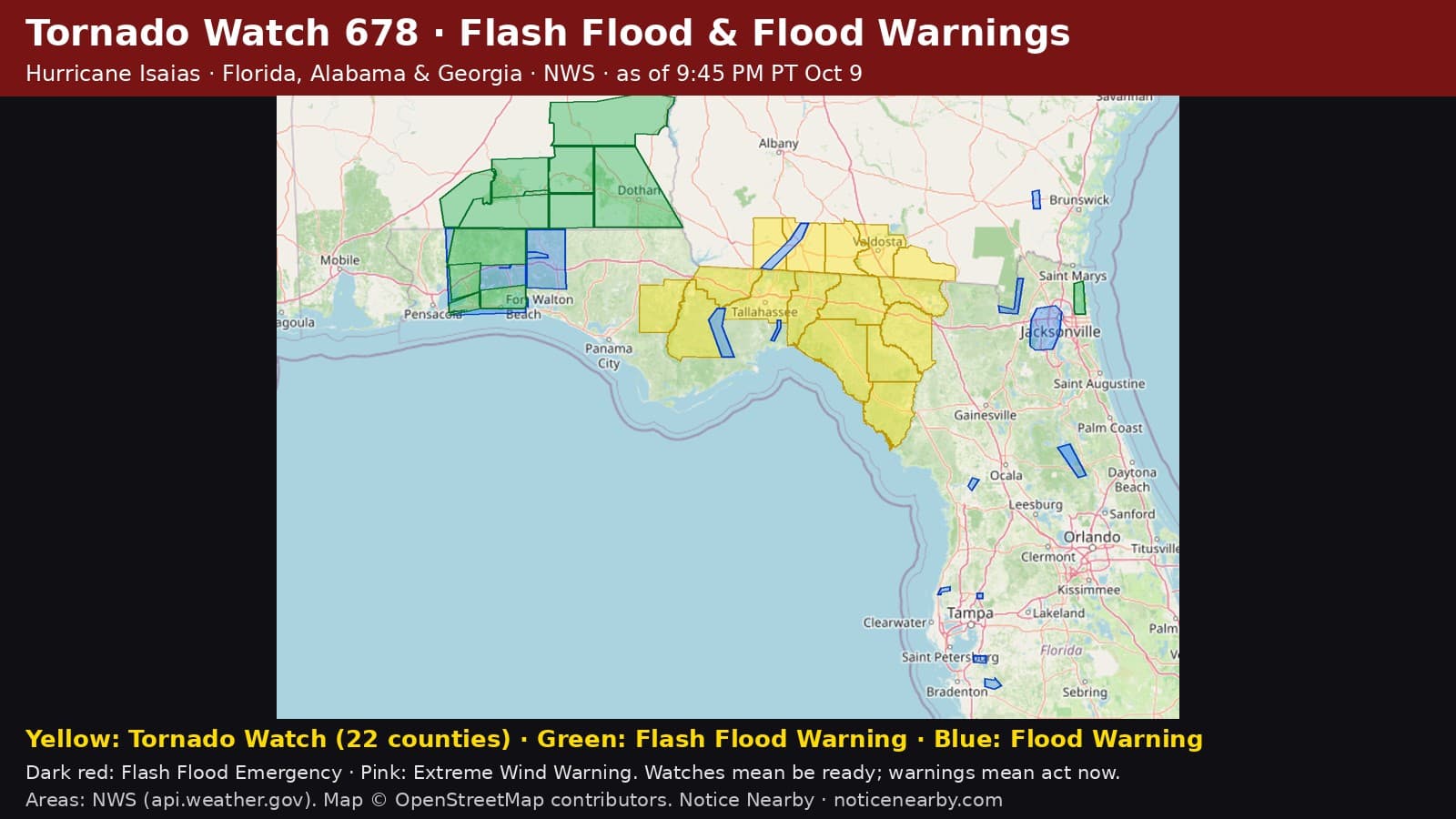
Calhoun County, Florida, is under National Weather Service Tornado Watch 678 until 3:00 a.m. PT (6:00 a.m. EDT Saturday) as Hurricane Isaias moves inland. A watch means tornadoes are possible; if a Tornado Warning is issued, take shelter immediately.
NWS Tallahassee, Florida placed Calhoun County in Tornado Watch 678, issued 5:54 p.m. PT Friday, Oct. 9 (8:54 p.m. EDT), and in effect until 3:00 a.m. PT Friday night (6:00 a.m. EDT Saturday, Oct. 10). Watch 678 replaces part of Tornado Watch 677. Hurricane Isaias's rain bands can spin up brief tornadoes with little warning, especially at night.
Counties in Tornado Watch 678 (NWS, as of 9:45 PM PT): Florida: Calhoun, Dixie, Franklin, Gadsden, Gulf, Hamilton, Jackson, Jefferson, Lafayette, Leon, Liberty, Madison, Suwannee, Taylor, Wakulla. Georgia: Brooks, Decatur, Echols, Grady, Lowndes, Seminole, Thomas.
Places NWS lists in this part of the watch include Abe Springs, Adams Beach, Alma, Apalachicola, Athena, Ausmac, Bainbridge, Bay City, Beachton, Bethel, Beverly, Blountstown, Blue Springs, Blue Springs, Boyd, Bradfordville, Brooks Co airport, Browntown, Bucell Junction, Buck Siding, Buckville, Cabbage Grove, Cairo, Capel, Capitola, Capps, Carbur, Carrabelle, Casa Blanco, Chaires, Chaires Crossroads, Chattahoochee, Cherry Lake, Clarksville, Cooks Hammock, Cross City, Cross City Airport, Dalkeith, Davis Park, Day, Decatur Co airport, Dillon, Dills, Dixie, Donaldsonville airport, Donalsonville, Drifton, Durham, Elpino, Empress, Fairchild, Festus, Fort Gadsden, Frink, Graceville, Grady Co airport, Grooverville, Hanover, Hanson, Hardin Heights, Hilliardville, Hines, Honeyville, Hopewell, Howard Creek, Jarrott, Jonesboro, Killearn Estates, Killearn Lakes, Little Hope, Littman, Lovett, Lynn, Maclay State Gardens, Madison, Malone, Marianna, Marysville, Mayo, Metcalf, Midway, Moncrief, Monticello, Nankin, Oak Grove, Odena, Old Town, Pasco, Perry, Pine Park, Pinetta, Port St. Joe, Quincy, Quincy Airport, Quitman, Richter Crossroads, Riverturn, Santa Clara, Scotts Ferry, Seminole State Park, Simsville, Sneads, Sopchoppy, St. Marks, Steinham Store, Sweetwater, Tallahassee, Thomasville, Tilton, Valdosta, Valdosta Regional Airport, Wakulla Springs, West Bainbridge, Wetumpka, Wewahitchka, White City, and Yellow Jacket.

Tornado safety, from NWS: a Tornado Watch means conditions are favorable for tornadoes, so be prepared to act quickly. Know your safe place (a basement, storm shelter or an interior room on the lowest floor, away from windows), keep more than one way to receive warnings, including a NOAA Weather Radio and phone alerts, and if a Tornado Warning is issued for your area, go to your safe place immediately. Mobile homes are not safe in a tornado; know where you will go ahead of time.
Hurricane Isaias, advisory by advisory from the National Hurricane Center: https://noticenearby.com/papers/tropical-storm-isaias-advisory-3-oct-7-2026
Source: National Weather Service Tallahassee, Florida Tornado Watch 678 (WCN) via api.weather.gov: https://api.weather.gov/alerts/urn:oid:2.49.0.1.840.0.ecd1de48348daf9527da7ce7cf64dfa624087d9a.001.2 · Storm Prediction Center watch page: https://www.spc.noaa.gov/products/watch/ww0678.html. Notice Nearby wrote this brief in its own words from NWS; times shown in Pacific time. More Calhoun County notices: https://noticenearby.com/fl/calhoun · Florida hub: https://noticenearby.com/fl
Source: the public notice on this register NN-ENV-fl-calhoun-tornado-watch-isaias-2026-10-0 · National Weather Service Tallahassee FL Tornado Watch 678.
This is a Notice Nearby local brief — an in-house explainer written from a government-posted notice on this register. It is not official minutes, not a newspaper story, and not Legal Publication.