Local brief
High Wind Warning and Flood Watch: Nye County, NV, as Tropical Storm Rachel moves in (through 5 a.m. PT Monday)
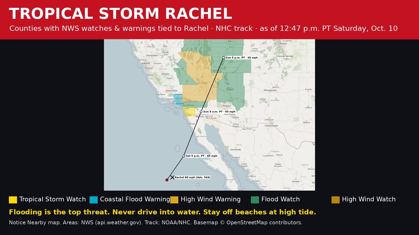
The National Weather Service has Nye County, Nevada, under a High Wind Warning until 8 p.m. PT Sunday, Oct. 11 and Flood Watches lasting as late as 5 a.m. PT Monday, Oct. 12, tied to Tropical Storm Rachel. Never drive into floodwater.
The National Weather Service office in Las Vegas, NV has a High Wind Warning for parts of Nye County from 5 a.m. PT Sunday, Oct. 11 until 8 p.m. PT Sunday, Oct. 11. NWS says it covers portions of northwest Arizona, southeast California, and southern Nevada. South winds 35 to 45 mph with gusts of 60 to 70 mph expected.
The National Weather Service office in Las Vegas, NV has a Flood Watch for parts of Nye County from 5 p.m. PT Saturday, Oct. 10 until 5 a.m. PT Monday, Oct. 12. NWS says it covers portions of southeast California, including the following areas, Death Valley National Park and Western Mojave Desert and south central Nevada, including the following area, Esmeralda and Central Nye County; and portions of northwest Arizona, including the following areas, Hualapai Mountains, Lake Havasu and Fort Mohave, Lake Mead - AZ side, Lake Mohave - AZ side, Northwest Deserts and Northwest Plateau, southeast California, including the following areas, Cadiz Basin, Eastern Mojave Desert, Morongo Basin and San Bernardino County-Upper Colorado River Valley, and Nevada, including the following areas, Lake Mead - NV side, Lake Mohave - NV side, Las Vegas Valley, Lincoln County, Northeast Clark County, Sheep Range, Southern Clark County, Spring Mountains-Red Rock Canyon and Western Clark and Southern Nye County. Flash flooding caused by excessive rainfall continues to be possible.
The National Weather Service office in Elko, NV has a Flood Watch for parts of Nye County from 11 p.m. PT Saturday, Oct. 10 until 5 a.m. PT Monday, Oct. 12. NWS says it covers portions of eastern, northeast, and south central Nevada, including the following areas, in eastern Nevada, White Pine. In northeast Nevada, Ruby Mountains and East Humboldt Range in Elko, South Central Elko and Southeastern Elko. In south central Nevada, Northeastern Nye and Northwestern Nye. Flash flooding caused by excessive rainfall continues to be possible. In addition, flash flooding is possible over recently burned areas like the former Ward Fire, Kearny Fire, Oxley Fire, Secret Pass Fire, Starr Valley Fire, Jones Fire, and Egberts Fire. Other burn scar locations in the watch area could also be affected.

At 11 a.m. PT Saturday, Oct. 10, the National Hurricane Center (NHC Intermediate Advisory 54A) placed Tropical Storm Rachel about 490 miles south-southwest of San Diego, California, moving northeast at 22 mph with top sustained winds near 60 mph. A northeastward to north-northeastward motion with a further increase in forward speed is expected through Sunday. On the forecast track, the center of Rachel is expected to approach northern Baja California today and move onshore tonight.
What to do: Never drive or walk into water on a road; turn around, don't drown. Washes, dips and low-water crossings can flood in minutes. If you live below a recent burn scar or a steep slope, be ready to leave quickly if heavy rain starts. Tie down or bring in patio furniture and trash cans, charge your phone, and treat any downed power line as live.
Follow Rachel advisory by advisory, with every county watch and warning: https://noticenearby.com/papers/tropical-storm-rachel-2026
Sources: NWS Las Vegas NV High Wind Warning via api.weather.gov (https://api.weather.gov/alerts/urn:oid:2.49.0.1.840.0.f5bcbdb4b8cdcda291c9be6f2a2875556c00f510.003.2); NWS Las Vegas NV Flood Watch via api.weather.gov (https://api.weather.gov/alerts/urn:oid:2.49.0.1.840.0.6572c16a5a4940ab3ea35f8cc6dbe46064aa3f15.002.1); NWS Elko NV Flood Watch via api.weather.gov (https://api.weather.gov/alerts/urn:oid:2.49.0.1.840.0.e193c38c68f6ab011937aa31402ba2c947441a66.002.1); NOAA National Hurricane Center (https://www.nhc.noaa.gov/text/MIATCPEP3.shtml). Notice Nearby wrote this brief in its own words. More Nye County notices: https://noticenearby.com/nv/nye
Source: the public notice on this register NN-ENV-nv-nye-tropical-storm-rachel-2026-10-10 · NWS Las Vegas NV · NWS Elko NV · National Hurricane Center.
This is a Notice Nearby local brief — an in-house explainer written from a government-posted notice on this register. It is not official minutes, not a newspaper story, and not Legal Publication.