Local brief
Ended: Flash Flood Warning for central Brewster County, TX — Marathon and Big Bend National Park, ended 3 a.m. CDT Wednesday
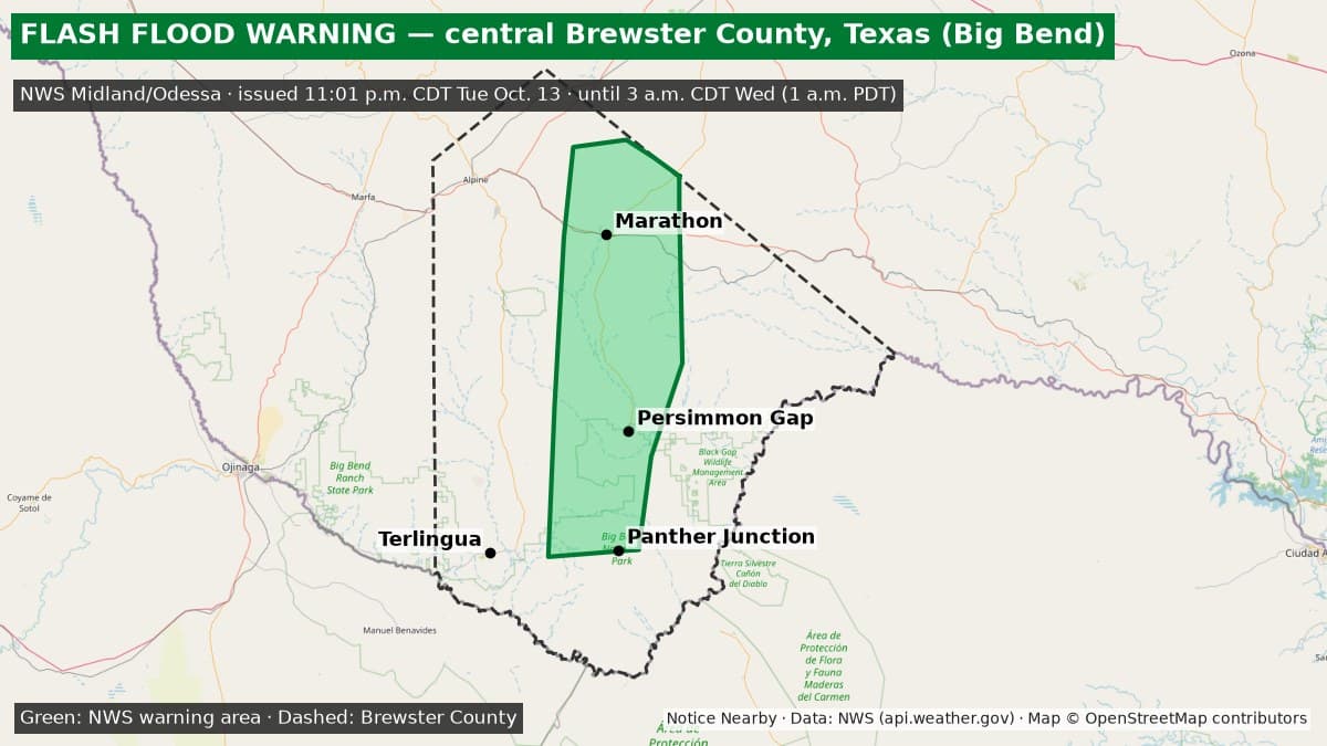
The National Weather Service Midland/Odessa Flash Flood Warning for central Brewster County, Texas, including Marathon, Panther Junction and Big Bend National Park, ended at 3 a.m. CDT Wednesday, Oct. 14 (1 a.m. PDT).
Ended: The Flash Flood Warning for central Brewster County, including Marathon, Panther Junction and Big Bend National Park (NWS Midland/Odessa FF.W.0229), ended at 3 a.m. CDT Wednesday, Oct. 14 (1 a.m. PDT) and is no longer on the active NWS alert list (checked 1:01 a.m. PDT Wednesday, Oct. 14). In its last update, NWS said the heaviest rain had ended but some roads and low-lying areas may still be flooded. Separate Flash Flood Warnings may still be in effect for other parts of Brewster County: https://noticenearby.com/briefs/tx-brewster-pecos-flash-flood-warning-2026-10-13 and https://noticenearby.com/briefs/tx-brewster-alpine-flash-flood-warning-2026-10-14. The details below are kept for the record. Source: https://api.weather.gov/alerts/active?area=TX.
Essentials: Flash Flood Warning from the National Weather Service in Midland/Odessa for central Brewster County, Texas. Issued 11:01 p.m. CDT Tuesday, Oct. 13 (9:01 p.m. PDT). In effect until 3 a.m. CDT Wednesday, Oct. 14 (1 a.m. PDT). NWS says flash flooding is ongoing or expected to begin shortly. A separate warning for southwestern Brewster County (Terlingua and Study Butte) runs until 2 a.m. CDT: https://noticenearby.com/briefs/tx-brewster-flash-flood-warning-2026-10-13
Get prepared: https://noticenearby.com/prepare

What is happening: At 11:01 p.m. CDT, Doppler radar showed thunderstorms producing heavy rain across the warned area. NWS expects rain to fall at 1 to 2 inches an hour. Small creeks and streams, highways, streets, underpasses and other low-lying or poorly drained areas can flood.
Places named by NWS: Panther Junction, Persimmon Gap, Marathon, Big Bend National Park, U.S. Highway 385, Santiago Peak, Terlingua Ranch Lodge and Terlingua Ranch Airport.
What to do: Turn around, don't drown. Most flood deaths happen in vehicles. NWS says to be especially careful at night, when flooding is harder to see. In hilly terrain there are hundreds of low-water crossings that can be dangerous in heavy rain. Do not try to cross flooded roads; find another route.
Until when: 3 a.m. CDT Wednesday, Oct. 14 (1 a.m. PDT). NWS can extend or cancel the warning early, so check https://www.weather.gov/maf/ for updates.
Sources: National Weather Service Midland/Odessa Flash Flood Warning via api.weather.gov (https://api.weather.gov/alerts/urn:oid:2.49.0.1.840.0.02780fe85f65affcb394c515cc8f0a6b5cbbda64.001.1). Verified on the active NWS alert list at 9:46 p.m. PDT Tuesday, Oct. 13. Notice Nearby wrote this brief in its own words. More Brewster County notices: https://noticenearby.com/tx/brewster
Source: the public notice on this register NN-NWS-20261013-KMAF-FF-W-0229 · National Weather Service Midland/Odessa TX.
This is a Notice Nearby local brief — an in-house explainer written from a government-posted notice on this register. It is not official minutes, not a newspaper story, and not Legal Publication.