Local brief
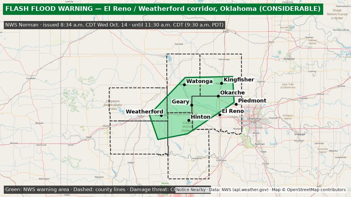
Ended: Flash Flood Warning (considerable): El Reno and Weatherford corridor, Oklahoma — Canadian, Kingfisher, Blaine, Caddo, Custer and Washita counties until 11:30 a.m. CDT Wednesday
The National Weather Service in Norman issued a Flash Flood Warning with a considerable damage threat at 8:34 a.m. CDT Wednesday, Oct. 14, for parts of Canadian, Kingfisher, Blaine, Caddo, Custer and Washita counties in Oklahoma, including El Reno and Weatherford, until 11:30 a.m. CDT. NWS says 5 to 9 inches of rain have fallen and life-threatening flash flooding is ongoing or expected.
Ended: Flash Flood Warning FF.W.0108 was no longer on the National Weather Service active alert list at 9:25 a.m. PDT Wednesday, Oct. 14; it had been scheduled to end at 11:30 a.m. CDT (9:30 a.m. PDT). Other NWS Norman Flash Flood Warnings remain in effect nearby: https://noticenearby.com/briefs/oklahoma-flash-flooding-roundup-2026-10-14
Essentials: Flash Flood Warning from the National Weather Service in Norman for northern Canadian County, southern Kingfisher County, southern Blaine County, northwestern Caddo County, southeastern Custer County and northeastern Washita County in Oklahoma. Issued 8:34 a.m. CDT Wednesday, Oct. 14 (6:34 a.m. PDT). In effect until 11:30 a.m. CDT Wednesday, Oct. 14 (9:30 a.m. PDT). NWS says flash flooding is ongoing or expected to begin shortly. NWS lists a CONSIDERABLE flash-flood damage threat and life-threatening flash flooding.
Get prepared: https://noticenearby.com/prepare

What is happening: At 8:34 a.m. CDT, Doppler radar and automated rain gauges showed thunderstorms producing heavy rain in Weatherford, Hydro, Bridgeport, Hinton, Geary, Okarche and Kingfisher. NWS says 5 to 9 inches of rain have fallen, and 2 to 4 more inches are possible. Small creeks and streams, urban areas, highways, streets, underpasses and other low-lying or poorly drained areas can flood.
Places named by NWS: El Reno, Weatherford, Watonga, Kingfisher, Piedmont, Hinton, Geary, Okarche, Hydro, Calumet, Corn, Eakly, Lookeba, Colony, Bridgeport, Greenfield, Concho, Cedar Lake and Omega.
What to do: Turn around, don't drown. Most flood deaths happen in vehicles. NWS says to be especially careful at night, when flooding is harder to see. Do not drive into flooded roads; find another route. Morning commuters should allow extra time and check routes before leaving. Avoid flooded creeks, streams and underpasses.
Until when: 11:30 a.m. CDT Wednesday, Oct. 14 (9:30 a.m. PDT). Overlapping NWS Norman Flash Flood Warnings also cover nearby areas: https://noticenearby.com/briefs/ok-canadian-flash-flood-warning-2026-10-14 (FF.W.0104, extended to 10:30 a.m. CDT) and https://noticenearby.com/briefs/ok-custer-flash-flood-warning-2026-10-14 (FF.W.0106 through 10:30 a.m. CDT). NWS can extend or cancel the warning early, so check https://www.weather.gov/oun/ for updates.
Sources: National Weather Service Norman Flash Flood Warning via api.weather.gov (https://api.weather.gov/alerts/urn:oid:2.49.0.1.840.0.3048e42fc5b2d0ed50695a08ec2688b370cccceb.001.1). Verified on the active NWS alert list at 6:53 a.m. PDT Wednesday, Oct. 14. Notice Nearby wrote this brief in its own words. More Canadian County notices: https://noticenearby.com/ok/canadian
Source: the public notice on this register NN-NWS-20261014-KOUN-FF-W-0108 · National Weather Service Norman OK.
This is a Notice Nearby local brief — an in-house explainer written from a government-posted notice on this register. It is not official minutes, not a newspaper story, and not Legal Publication.