Local brief
Oklahoma flash flooding: 2 NWS Norman Flash Flood Warnings in effect Wednesday, Oct. 14
The National Weather Service in Norman has 2 Flash Flood Warnings in effect across western and central Oklahoma on Wednesday, Oct. 14. NWS Norman says Oklahoma City set a daily rainfall record with 3.51 inches by mid-morning.
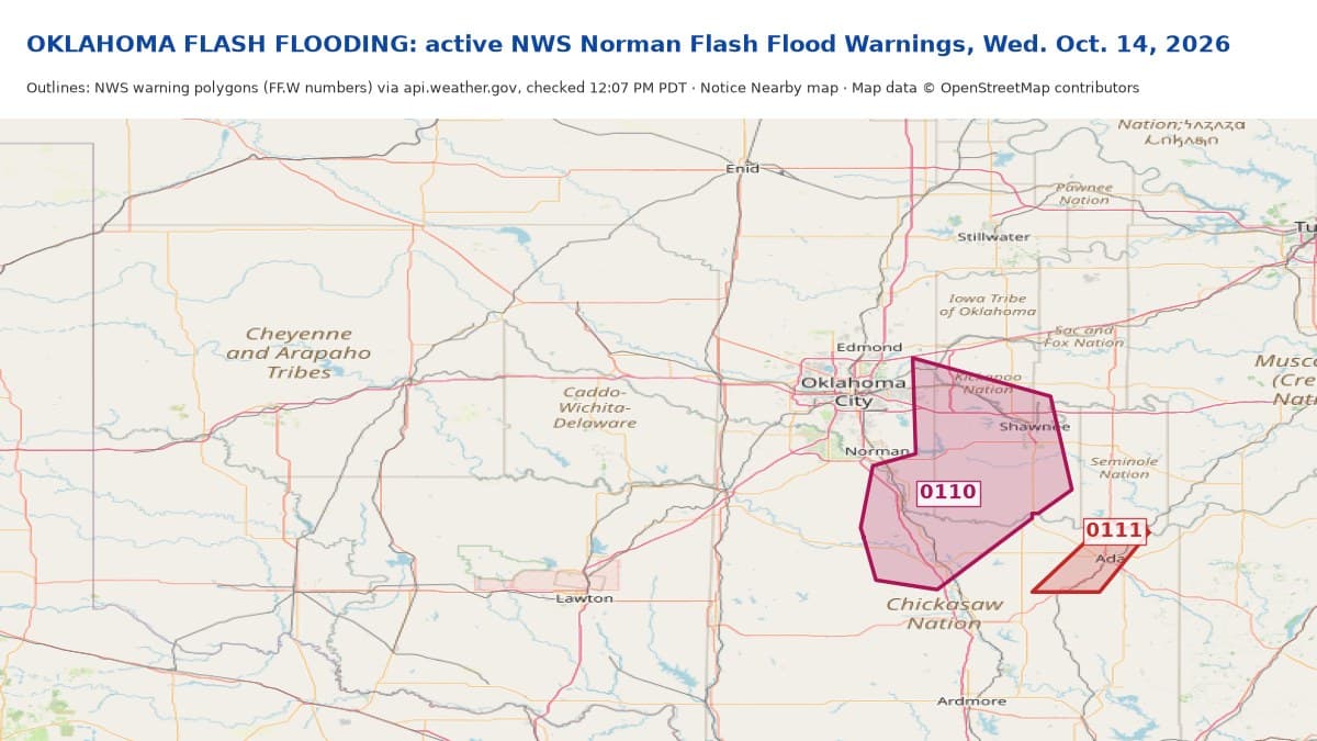
Essentials: As of 12:07 PM PDT Wednesday, Oct. 14, the National Weather Service in Norman has 2 active Flash Flood Warnings in Oklahoma. A Flood Watch from NWS Norman covers much of western, central and northern Oklahoma until 1 p.m. CDT Thursday (11 a.m. PDT).
Flash Flood Warning FF.W.0110: Cleveland and Pottawatomie counties and parts of Lincoln, McClain, Oklahoma and Garvin counties, including eastern Oklahoma City, eastern Norman, Midwest City, Shawnee, Tecumseh, Pauls Valley and Purcell. Until 2:15 p.m. CDT (12:15 p.m. PDT). NWS: 2 to 3 inches have fallen; 1 to 2 more possible. Notice Nearby brief: https://noticenearby.com/briefs/ok-shawnee-midwest-city-flash-flood-warning-2026-10-14
Flash Flood Warning FF.W.0111: Pontotoc. Until 3 p.m. CDT (1 p.m. PDT). Notice Nearby brief: https://noticenearby.com/briefs/ok-pontotoc-flash-flood-warning-0111-2026-10-14

Ended: FF.W.0108 — no longer on the NWS active alert list at 9:25 a.m. PDT; had been scheduled to end 11:30 a.m. CDT (9:30 a.m. PDT). Brief: https://noticenearby.com/briefs/ok-el-reno-weatherford-flash-flood-warning-2026-10-14
Ended: FF.W.0106 — no longer on the NWS active alert list at 10:23 a.m. PDT, before its scheduled end of 12:30 p.m. CDT (10:30 a.m. PDT). Brief: https://noticenearby.com/briefs/ok-custer-flash-flood-warning-2026-10-14
Ended: FF.W.0107 — no longer on the NWS active alert list at 10:39 a.m. PDT, before its scheduled end of 12:45 p.m. CDT (10:45 a.m. PDT). Brief: https://noticenearby.com/briefs/ok-cleveland-flash-flood-warning-2026-10-14
Ended: FF.W.0105 — no longer on the NWS active alert list at 10:54 a.m. PDT; it was scheduled to end at 1 p.m. CDT (11 a.m. PDT). Brief: https://noticenearby.com/briefs/ok-oklahoma-flash-flood-warning-2026-10-14
Ended: FF.W.0104 — no longer on the NWS active alert list at 11:27 a.m. PDT, before its scheduled end of 2 p.m. CDT (noon PDT). Brief: https://noticenearby.com/briefs/ok-canadian-flash-flood-warning-2026-10-14
Ended: FF.W.0109 — expired at 2 p.m. CDT (noon PDT). Brief: https://noticenearby.com/briefs/ok-seminole-wewoka-flash-flood-warning-2026-10-14
Record rain: NWS Norman posted at 9:55 a.m. CDT that Oklahoma City had surpassed its daily rainfall record with 3.51 inches so far; the previous record was 2.45 inches, set in 1956. NWS said it is the most rain in a single day in over 2 years. https://x.com/NWSNorman/status/2110384088553083061
What to do: NWS says turn around, don't drown when encountering flooded roads. Most flood deaths occur in vehicles. Be alert for water on roadways.
Get prepared: https://noticenearby.com/prepare
Watch: Notice Nearby YouTube Short on this flooding: https://www.youtube.com/shorts/dP9j0NKlli4
Follow NWS Norman on X: https://x.com/NWSNorman. Posts used: https://x.com/NWSNorman/status/2110384088553083061, https://x.com/NWSNorman/status/2110403517999386672, https://x.com/NWSNorman/status/2110365024585720232, https://x.com/NWSNorman/status/2110337807772160456
Sources: National Weather Service Norman Flash Flood Warnings via api.weather.gov (https://api.weather.gov/alerts/active?area=OK), verified at 12:07 PM PDT; NWS Norman posts on X listed above. Warnings can be extended or canceled early; check https://www.weather.gov/oun/. Map: Notice Nearby, NWS warning polygons; map data © OpenStreetMap contributors. Notice Nearby wrote this brief in its own words.
Source: the public notice on this register NN-NWS-20261014-KOUN-FF-ROUNDUP · National Weather Service Norman OK.
This is a Notice Nearby local brief — an in-house explainer written from a government-posted notice on this register. It is not official minutes, not a newspaper story, and not Legal Publication.